Saturday, July 29, 2017

Land, Family Domains, Anastasia Book Series

Dr. Leonid Sharashkin publishes English-language books about Anastasia, a Russian woman with remarkable abilities and insights. The author of these books is Russian entrepreneur Vladimir Megre, who describes his meetings with Anastasia in the Siberian taiga. Megre’s nine books about Anastasia and her message of hope to the world, collectively known as the Ringing Cedar Series, inspired the Anastasia Ecovillage Movement in Russia.

The information contained within the Anastasia books, ideas on practical application of her key concept.  One of these is the role of the fully developed human being (referred to in the books as “Man,” with a capital “M”) working with nature to create a harmonious and abundant life. The cultural roots of this vision lie in what the books describe as the Vedic traditions of Russia.

The essence of what she describes is that Man is incomplete without Land. The history of what we are told to call civilization by our schools and authority figures has been the progressive separation of people from the land which had nurtured them and their forbears for millennia, replacing the nurture of nature with the control of culture .

A core element of the vision expressed in the books is that true democracy, abundance, and ecological resilience becomes possible as people return to the structure of what Anastasia calls a “Family Domain” — one hectare of land (2.5 acres) with woods, fruit trees, a vegetable garden, and a small pond — owned outright by a family and passed down through the generations. This hectare becomes a diverse garden – providing unique nourishment to those who live within its energetic boundaries, continuity and connection through the generations, and a base from which true security can be experienced.


A kin-domain would have some or all of the following features
A dam or pond to provide a water supply
Living fences
Trees planted to provide wood for future generation’s buildings and for firewood where needed.
Bee-hives
Farm and companion animals
A food forest
Vegetable patch
An area for the cultivation of grains

Many of these aspects can be easily integrated in the one area.

A kin-domain is not about spending all day working the land for your next feed, or spending hours grinding grain so you can bake tomorrow’s loaf of bread. It’s about creating a self sustaining system that provides all you need. It’s about working with nature, so that nature will work for you.

About one third (one Quarter to a half) is to be planted as forest for wood. This can also have fruit and nut trees as week as vines, herbs, berries etc planted amongst it. Partly this acts as animal habitat and partly provides wood for future generations building materials. The area can also provide some grazing for farm animals such as goats, sheep, cattle etc which can be used for milk or wool. About 1-4% is used for dams, as well as for water supply, it can be planted with edible aquatic plants, have fish and crustaceans etc. A large proportion of the remaining area is devoted to the intentional food forest area and the production of grains.  Near the house would be a vegetable patch. Of course both the vegetables and grains could and should be grown within the food forest areas. Bee hives can be placed anywhere within the wood forest, or other areas.

The essential thing is to let yourself be inspired with free and creative thought when planting your garden of eden, and to let yourself be guided by your intuition, passion and the feelings of love and joy.

Further, a “Space of Love,” as the books assert, is created within such a one-hectare plot, and is part of the energy that helps to return people to right relationship with one another and with the natural world.

At this point, hundreds of Anastasia-inspired ecovillage projects are in the planning stages in Russia, and some are already established. Kovcheg Ecovillage was founded in 2001 when 4 families leased — under a 49-year government lease, and at no charge — about 297 acres (120 hectares) of former agricultural land 87 miles (140 km) southwest of Moscow, in the Kaluga region. As Anastasia advised, people built their homes on individual one-hectare (2.5 acre) plots. In their first 8 years they built more than 100 homes, though not all are finished and heated for winter use. They built the houses mostly by themselves, and at the rate of between 12 and 20 a year.

Agribusiness interests propose that broad-scale industrial agriculture is the only model that can provide reliable, inexpensive food and that the toxicity of inputs, soil depletion and energy inefficiency of the system is acceptable due to a lack of alternatives.

Thus far, this view has been backed solidly by the USDA to the tune of billions in agricultural subsidies that underpin this model — financing the destruction of America's soil and food quality, and rewarding industrial agribusiness as the model to succeed.

But millions of home gardeners in Russia disprove all these ideas and offer a model in which people regain central control of their food system in a very direct way, by growing the majority of their food themselves. In a country with corporate farms using 83 percent of the agricultural land, some 35 million families produce more than 50 percent of the country’s food, growing on small plots which are typically some 25 x 35 yards in size.

In 2016 there were 337 settlements in Russia, seen registered on www.anastasia.ru website.

Links

http://www.eco-kovcheg.ru/index_en.html
http://www.ecovillagenews.org/wiki/index.php/From_Russia_with_Love
http://www.sustainableecovillages.net/kin_domains.php
http://kinsdomain.weebly.com/anastasias-vision.html


Monday, June 19, 2017

Real Estate; History of the Land in Canada

Land ownership in Canada is held by governments, Native groups, corporations, and individuals.

Since Canada uses primarily English-derived common law, the holders of the land actually have land tenure (permission to hold land from the Crown) rather than absolute ownership.

The majority of all lands in Canada are held by governments in the name of the monarch and are called Crown Lands. About 89% of Canada's land area (8,886,356 km²) is Crown Land, which may either be federal (41%) or provincial (48%); the remaining 11% is privately owned.

Most federal Crown land is in the Canadian territories (Northwest TerritoriesNunavut and Yukon), and is administered on behalf of Aboriginal Affairs and Northern Development Canada; only 4% of land in the provinces is federally controlled, largely in the form of National ParksIndian reserves, or Canadian Forces bases. In contrast, provinces hold much of their territory as provincial Crown Land, which may be held as Provincial Parks or wilderness.

The Crown also gave tenure to much of Canada to a private company, the Hudson's Bay Company (HBC) which from 1670 to 1870 had a legal and economic monopoly on all land in the Rupert's Land territory (identical to the drainage basin of Hudson Bay), and later the Columbia District and the North-Western Territory (now British Columbia, the Yukon, the Northwest Territories, and Nunavut) were added to the HBC's lands, making it one of the largest private landowners in world history. In 1868 the Imperial Parliament passed the Rupert's Land Act that saw most of its land ownership transferred to the Dominion of Canada.
After Canada acquired the HBC's land in 1870, it used the land as an economic tool to promote settlement and development. Under the Dominion Lands Act system of 1871, huge areas were given to the Canadian Pacific Railway to fund its transcontinental line, other areas were reserved for school boards to be sold to fund education, and the rest was distributed to settlers for agriculture. Settlers paid a $10 fee and agreed to make some improvements within a specified time for 180 acres (73 ha) of land. 

 The Crown is a corporation sole that represents the legal embodiment of executive, legislative, and judicial governance in the monarchy of each country. These monarchies are united by the personal union of their monarch, but they are separate as states. The concept of the Crown developed first in the Kingdom of England as a separation of the literal crown and property of the nation state from the person and personal property of the monarch. The concept spread through English and later British colonisation and is now rooted in the legal lexicon of the other 15 independent realms and the three Crown dependencies. In this context it should not be confused with any physical crown, such as those of the British royal regalia.
The term is also found in expressions such as crown land, which some countries refer to as public land or state land, as well as in some offices, such as Minister of the Crown, crown attorney, and crown prosecutor (other terms being district attorneystate prosecutor, or public prosecutor).

As the Dominion of Canada was taking its first steps, its political leaders were eyeing a vast area of land to the west of the new nation. 

An enormous territory called Rupert's Land was up for sale. It encompassed almost eight million square kilometers, including most of the prairies, and parts of what are now northern Quebec, northern Ontario, and Nunavut. The once powerful Hudson's Bay Company controlled the area. But the British fur trade giant had been in decline for years and it was now preparing to sell Rupert's Land.

The Americans, who had just paid Russia $7.2 million for Alaska in 1867, were looking for other properties to expand the Republic and eyed the territory.

But Canada saw Rupert's Land as the natural extension of its new nation which included Nova Scotia, New Brunswick, Ontario and Quebec.

George Brown, editor of The Globe and a Father of Confederation, described it as "the vast and fertile territory which is our birthright - and which no power on earth can prevent us occupying." 

The Hudson's Bay Company was prepared to sell to the Americans who would pay top dollar, but the British government made it clear it wanted the territory to be sold to Canada.

On March 20, 1869, the Hudson's Bay Company reluctantly, under pressure from Great Britain, sold Rupert's Land to the Government of Canada for $1.5 million. The sale involved roughly a quarter of the continent, a staggering amount of land, but it failed to take into account the existing residents - mainly Indians and Mtis.

This fact was not lost on Prime Minister John A. Macdonald.

"No explanation it appears has been made of the arrangement by which the country is to be handed over," Macdonald told political ally George-Etienne Cartier. "All these poor people know is that Canada has bought the country from the Hudson's Bay Company and that they are handed over like a flock of sheep to us."

But Macdonald would discover that expanding a nation was more complex than just buying real estate. The people of the new territory would show that they had no intention of being shepherded quietly into a union with Canada.


corporation sole is a legal entity consisting of a single ("sole") incorporated office, occupied by a single ("sole") natural person. A corporation sole is one of two types of corporation, the other being a corporation aggregate.

 This allows corporations (often religious corporations or Commonwealth governments) to pass without interval in time from one office holder to the next successor-in-office, giving the positions legal continuity with subsequent office holders having identical powers and possessions to their predecessors.

Rupert's Land, or Prince Rupert's Land, was a territory in British North America consisting of the Hudson Bay drainage basin, a territory in which a commercial monopoly was operated by the Hudson's Bay Company for 200 years from 1670 to 1870, although numerous aboriginal groups lived in the same territory and disputed the sovereignty of the area. 
The area once known as Rupert's Land is now mainly a part of Canada, but a small portion is now in the United States of America. It was named after Prince Rupert of the Rhine, a nephew of Charles I and the first Governor of the Hudson's Bay Company. In December 1821 the HBC monopoly was extended from Rupert's Land to the Pacific coast.
Areas belonging to Rupert's Land were mostly in present-day Canada and included the whole of Manitoba, most of Saskatchewan, southern Alberta, southern Nunavut, and northern parts of Ontario and Quebec. It also included present-day United States territory, including parts of the states of Minnesota and North Dakota and very small parts of Montana and South Dakota. 

The southern border west of Lake of the Woods to the Rocky Mountains was the drainage divide between the Mississippi and Saskatchewan watersheds until the London Convention of 1818 substituted the 49th Parallel.

When granted the English Royal Charter in 1670 by King Charles II of England, the Hudson’s Bay Company, under the governorship of the king's cousin Prince Rupert of the Rhine, was granted “the sole Trade and Commerce of all those Seas, Streights, Bays, Rivers, Lakes, Creeks, and Sounds, in whatsoever Latitude they shall be, that lie within the entrance of the Streights commonly called Hudson's Streights, together with all the Lands, Countries and Territories, upon the Coasts and Confines of the Seas, Streights, Bays, Lakes, Rivers, Creeks and Sounds, aforesaid, which are not now actually possessed by any of our Subjects, or by the Subjects of any other Christian Prince or State [sic]”, “and that the said Land be from henceforth reckoned and reputed as one of our Plantations or Colonies in America, called Rupert's Land ” 

The Royal Charter made the “Governor and Company …, and their Successors, the true and absolute Lords and Proprietors, of the same Territory, Limits and Places aforesaid, and of all other the Premisses ,” and granted them the authority “to erect and build such Castles, Fortifications, Forts, Garrisons, Colonies or Plantations, Towns or Villages, in any Parts or Places within the Limits and Bounds granted before in these Presents, unto the said Governor and Company, as they in their Discretion shall think fit and requisite.

royal charter is a formal document issued by a monarch as letters patent, granting a right or power to an individual or a body corporate. They were, and are still, used to establish significant organisations such as cities (with municipal charters) or universities and learned societies. Charters should be distinguished from warrants and letters of appointment, as they have perpetual effect. Typically, a Royal Charter is produced as a high-quality work of calligraphy on vellum. The British monarchy has issued over 980 royal charters. Of these about 750 remain in existence. 

Links:

https://en.wikipedia.org/wiki/Land_ownership_in_Canada
https://en.wikipedia.org/wiki/Commonwealth
https://en.wikipedia.org/wiki/Rupert%27s_Land
https://en.wikipedia.org/wiki/Royal_charter


Thursday, June 1, 2017

St Lawrence Hall - Survivors Building Toronto Ontario

 St. Lawrence Hall was built in 1850 as a meeting place for public gatherings, concerts and exhibitions. Restored to its original grandeur in 1967, the Hall with its three major rooms continues to serve as a breathtaking venue to inspired special occasions certain to make a lasting impression.

St. Lawrence Hall is a meeting hall in Toronto, Ontario, located at the corner of King Street East and Jarvis Street. It was created to be Toronto's public meeting hall home to public gatherings, concerts, and exhibitions. Its main feature was a thousand-seat amphitheater. For decades the hall was the centre of Toronto's social life, before larger venues took over much of this business. Today the hall continues as a venue for events including weddings, conferences, and art shows.

The location was previously part of the Market Square area, and had been the site of the first permanent market buildings. A fire in 1841 caused the northern portions of this building to be pulled down, leading to the building of the current St. Lawrence Market in 1850 a block south at what was then Palace Street, and today known as Front Street. The vacated area at the corner of King and Jarvis was in the heart of the growing community. The Renaissance Revival style building was designed by William Thomas.

It was here that prominent politicians such as John A. Macdonald and George Brown, Fathers of Confederation, addressed the people of Toronto. It was the main venue for musicians and other performers who came to the city. The lower levels were integrated into the market and were home to stores and businesses.

A third storey section of the building was known as St. Patrick Hall, an important meeting place for the Irish Catholic Benevolent Union.

William Thomas (c.1799-26 December 1860) was an architect of both England and Canada. He immigrated to Toronto with his wife and 10 children from Leamington Spa, England due to the economic crisis in 1837. After his emigration to Toronto, his career as a city engineer and architect prospered. One of his well-recognized successful works in architecture after his settlement is St. Lawrence Hall.
Thomas’ work was undoubtedly influenced by 16th-century Italian Renaissance architecture, the central Roman temple that consists of the pediment, four engaged Corinthian columns, and the three arches underneath very closely resemble the work of an Italian Classist architect, Andrea Palladio.

A public hall flanked by shops was built in 1831 as part of a rectangle of buildings making up York's market square. When York was incorporated as Toronto in 1834, the hall became the City Hall for a decade until its successor was built nearby. After the great fire of 7 April 1849 burned down much of the town centre, the area was revitalized by the construction of St. Lawrence Hall.

In 1967 it was designated a national historic site and restored as part of a centennial project in the City of Toronto.

In 1971 a planning board report and consultant recommended to the city that the South Market be demolished. But adamant citizen groups fought back and persuaded the city to renovate.

One wall of the original jail remains in the basement, says historian Bell, who is thankful the South Market and St. Lawrence Hall didn’t become prey to the “urban knockdown in the 1950s and 1960s” when “25,000 historical buildings” in the city were torn down.

Around 1900, the ground floor was home to a branch of the Dominion Bank and a stove and furnce store. The arched entrance at the centre led to a small shopping arcade. Image: Toronto Public Library, E 10-79.

As planned by architect Thomas, the ground floor was leased to retailers. There were stores on either side of the indoor shopping arcade and also facing the surrounding streets. 

Early photos show gigantic signs for businesses such as the Toronto Tea Company and Graham’s Temple of Fashions crowding the fine, if eccentric, architectural detailing.

Much of the space on the east side of the building was leased to the Irish Catholic Benevolent Union, which advertised its presence with a sign for “St. Patrick’s Hall.”
 

Among the notable features of the exterior are columns that are a close copies of those used on the ancient Temple of Jupiter Stator in Rome. ( Survivor Style)

 Closer to the ground, on King Street, a number of carved men’s faces peer out from the sides of the building, representing fictional deities of Lake Ontario, the Niagara, and St. Lawrence rivers.

Near the roof, also facing King Street, the figure of Britannia, an Indigenous man with bow and quiver, and the crest of the Royal Arms of England form the City of Toronto coat of arms. The city’s motto at the time, “Industry, Intelligence, Integrity,” is carved below.

The building was topped with a public clock connected to a 966-kilo bell that chimed the hour. In the 1850s, this timekeeping device was a critically important piece of infrastructure.

Before affordable watches, the clocks at St. Lawrence Hall and Union Station were among the few ways of knowing the time of day on the street with any degree of accuracy. 

Scientists at the observatory at University College send a signal to the town’s fire halls when the sun approached its peak at 11:55 am.

In September 1964, the Ontario Municipal Board approved the city’s $1.2-million plan to purchase land around the Hall with $750,000 of that amount earmarked for the restoration of old building.

The St. Lawrence Hall was constructed over the period 1850-1851 on a site at the southwest corner of King and Jarvis Sts. that at the time was in the very heart of the young city.


Monday, April 24, 2017

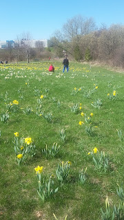
The Field of Gold - 5500 Daffodil Garden in Aurora

 
The Arboretum follows a green space from Wellington Street to St. John side road. It has pave and unpaved trails, lovely bridges and a large variety of flowers, trees and shrubs, and native species. It is home to butterflies, song birds and small mammals.

 Daffodil Garden is apparently 3 years old (2017) a beautiful initiative of volunteers from Aurora belonging to Aurora Community Arboretum


A large memorial daffodil garden .
October 29th 2017 an enthusiastic group of volunteers planted 1,000 daffodil bulbs in the Arboretum. This will bring a grand total of 5,500 daffodils in the Field of Gold.

The trail continues north and eventually joins the Tom Taylor trail in Newmarket. You can follow the Tom Taylor trail north beyond Green Lane to the Rogers Reservoir. 
 
The 100 acre park has other facilities such as playground for children and baseball diamonds and soccer fields. There is also a community center that has a gym, a pool and a hockey rink open all year round.
Like much of the land in York Region, this was forested land before the settlers came and actively farmed the area. The Aurora Community Arboretum aims to help restore some of that former forest grandeur.
 
The idea for the Aurora Arboretum began about 1995 and it was established in 1996. The primary focus of the individuals working on the project at that time was to plant caliper trees as memorials. These first plantings are located in the valley of the East Holland River, just west of the Aurora Town Hall. The planting of the memorial trees (as of 2007 called Commemorative Trees) is done under Adopt-a-Park Agreements with the Town of Aurora.
 
 A 200 years old healthy tree was cut April 2017. here is the result. These old trees should be protected even tough the carved sculpture is beautiful. That was a tree older that the town itself.
 
 
Links
 
http://www.auroraarboretum.ca/get-involved/commemorate